Understand the oceanic forecasting and how it differs from coastal forecasting
Waves behave differently in the ocean than when they arrive at the beach. That's why there are differences in the forecast. Come and understand, as Professor Swell explains!
01/Dez/2021 - DOUGLAS NEMES, PHD.Currently there are at least 15 global atmospheric and ocean agencies that have the operational capacity to generate global meteorological and oceanographic forecast. This means that in these research and development centers there are gigantic computational efforts, whose series processors (cluster) can solve several physical equations of energy transfer and movement along a computational grid/mesh that surrounds the entire planet.
[ MAKE THE SURFGURU WAVE FORECASTING COURSE]
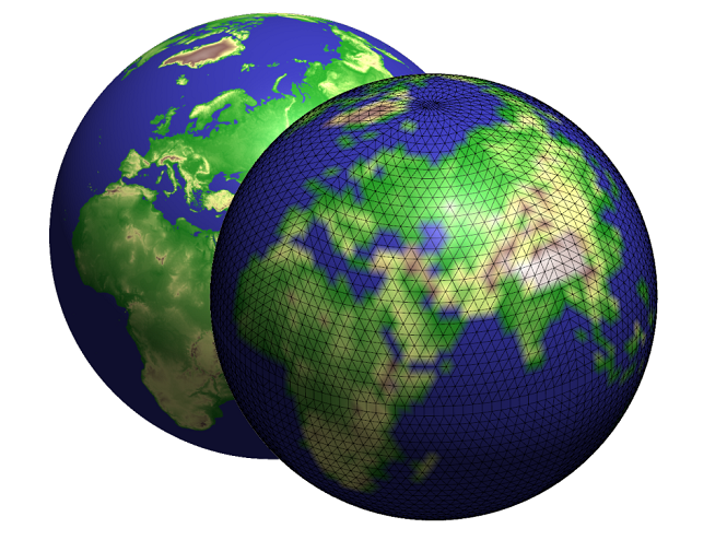
Figure 1. ECMWF computational mesh.
The computational domain is the surface of the Planet, where the computational grid or also called numerical mesh, is created. like a “fishing net” that covers the planet. This analogy is for you understand that the nodes of the fishing net are where hundreds of calculations of the physical processes that occur in the atmosphere are being carried out. The connection between nodes is where the results of these equations are transmitted, which together generate the hydrodynamics global mica.
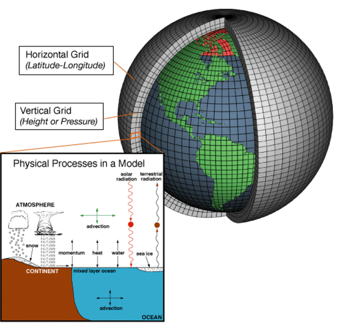
< span id="docs-internal-guid-252bdaa5-7fff-c0dd-109d-c304c4c8d4ea">Figure 2. Physical calculations of the planet's hydrodynamics.
This way, it gives to imagine that the smaller the “hole in the fishing net” the “smaller fish will be held together with the big fish”. This is the resolutionof the computational mesh: the smaller the distance between the nodes, the greater the distance. the spatial resolution of the calculations and, consequently, better will be the representation of atmospheric phenomena. On the other hand, the greater the distance between the nodes of the numerical calculation grid, the greater the number. the computational effort. See some examples:
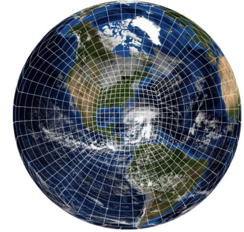
< span id="docs-internal-guid-252bdaa5-7fff-c0dd-109d-c304c4c8d4ea">Figure 3. NOAA GFS computational mesh.
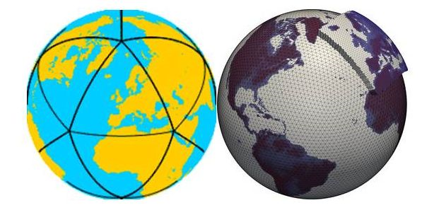
< span id="docs-internal-guid-252bdaa5-7fff-c0dd-109d-c304c4c8d4ea">Figure 4. ICON computational mesh.
To be able to make a global model of this type run reliably with these results, large investments are necessary. The most famous atmospheric and ocean agencies are the United States, European and German agencies, respectively NOAA (https:/ /www.noaa.gov/), ECMWF (https://www.ecmwf.int/) and GWS (https://www.dwd.de/). They can make it available for free the results of your atmospheric and global wave models. Many other companies request this data and present it in their respective layouts and/or other forms of statistics.
[ TAKE THE PREDICTION COURSESURFGURU WAVE ILLDEO]
Furthermore, through the results of the global atmospheric model there are companies that feed their own numerical wave models, generating wave forecasts. Magicseaweed (magicseaweed.com.br) is perhaps the oldest company to present wave forecasts on a website with its own layout and statistics, offering its own way of running the WWIII global wave model (Wave Watch III, which is widely used today) from the NOAA atmospheric source (GFS). Surfguru today also runs this same model, using the NOAA database (GFS) as its source.
Understand the relationship between global wave models and the global atmospheric model
A global wave model needs to be powered by a wave generating source: the winds. Therefore, the global wave model must necessarily be coupled to a global atmospheric model. Now know that: the generation of waves is proportional to the wind squared. This means that any atmospheric phenomenon poorly resolved by the global atmospheric model will be transferred to the wave model. Therefore, coastal wave template, which has the bathymetry of the shallow continental shelf. This background information comes from nautical charts. One of the pioneering companies in this is; Waves (waves.com.br), which in partnership with the FURG university, generated an operational coastal wave model. This means that, from a global source of atmospheric hydrodynamics, a global wave model is created. coupled and soon after, a coastal wave model was coupled. This coastal model can compute wave phenomena in shallow waters and represents very well the reality of each location on the coast.
[ TAKE THE SURFGURU WAVE FORECASTING COURSE]
So what is it? the best wave model to be seen, Global or Coastal?
Response: both. Globally you will will identify the sources and how the waves are being dispersed until on your beach. Furthermore, it gives to check other generation zones close to the coast. Now In a coastal wave model you will learn how to use a coastal wave model. should identify how the waves are arriving at the beach, that is, how they are changing direction (refraction), converging or diverging, refracting in some obstacle (island, jetties, etc. ) and losing energy. Unfortunately, coastal models also lack resolution, not allowing us to see waves rising on reefs or slabs, for example.
Is there a better alternative?
The most revolutionary thing would be to couple a morphodynamic beach model to the coastal wave model. This would be possible if all surf breaks had real bottom information in the shoreline zone (3m to 10m), wave breaking zone (0.5m to 3m or more), wave breaking zone (0.5m to 3m or more), surf area (depths after wave break up to 0.1m) and splash zone (0.2 to 0m). In addition, a complete granulometry of all these morphological zones of the beach, generating a sedimentological facies map of the entire beach. With this, it would be possible to represent in the most realistic way possible the beach's response to the waves expected to arrive at the beach. It would be possible to predict the formation of sandbanks, ditches, return channels, etc. Perfect surf days would be predicted with much more accuracy.
Below are two drawings (plan and profile) of the beach to represent the hydrodynamics and morphodynamics of the beach. mica. All these variables must be properly represented in a mophodynamic model of the beach, which would be incorporated into a coastal wave model, which in turn would be integrated into a model of waves. quiltgiven to the global wave model and, finally, the latter coupled to a global atmosphere model. This means that the task is not possible. It's as simple as that and not even cheap.
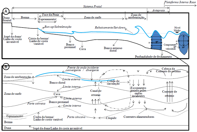
< span id="docs-internal-guid-252bdaa5-7fff-c0dd-109d-c304c4c8d4ea">Figure 6. A) beach profile with morphodynamic and hydrodynamic features . B) Beach plan with morphodynamic and hydrodynamic features.
Suggestion for further reading:
- How and why waves form
- Influence of shallow waters on wave formation
- Types of waves and influence of the bottom on their breaking
-----
What if you If you want to delve a little deeper into wave forecasting, we recommend the Wave Forecasting Course at Surfguru. With it you can surf. You will be able to use prediction to your advantage through basic concepts and practical tips!
The course é completely online, with approximately 4 hours of recorded classes and in it you will be able to learn more. You will learn the entire theory of wave formation: from how they form, how they move, to how they move. their arrival on the beach. He offers you everything, EVERYTHING, so that you can enjoy it. be able to correctly interpret the forecast.
Who has already studied? is PRO subscribers have an exclusive discount through our Advantages Club. If you is not yet available. PRO, try for 30 days free using the CURSO30 coupon. Let's go?
---------------------------------------------------------- ---
Douglas Nemes is He is a former competitive surfer, who had the opportunity to take all the empirical knowledge acquired in the waves of countless beaches he visited on this planet into the academy. Douglas graduated as a Physical Oceanographer at UNIVALI. He completed a Master's degree in Coastal and Ocean Systems at the Federal University of Paraná. UFPR in 2011. In 2016, he completed his PhD in Oce & acirc; nica Engineering at the Federal University of Rio de Janeiro UFRJ, COPPE Research and Engineering Institute, whose research institute & eacute; the most important in the Americas. Finally, in 2018 he completed a post-doctorate in Coastal Engineering, in a partnership between UFRJ and the Federal University of Pará. UFPA. Over almost 20 years of academic work, Dr. Nemes developed techniques to qualify wave breaking on ocean beaches, published national and international scientific works on the main meteorological phenomena on the south coast of South America and the development of a multifunctional coastal protection technology capable of recovering eroded beaches, generating perfect conditions for the practice of water sports. Currently works atthe coordination of hydrographic surveys and data processing for coastal engineering in Brazilian ports and waterways, in order to be used by the Hydrography Center of the Brazilian Navy in updating nautical charts.< /p>
---------------------------------------------------------- ---
Instagram: @surfingandstudying
Vídeos | Mais Vídeos
-
Festival de Surf e Ciência, cultura oceânica e limpeza de praia em Regência - ES
-
Expression Session #7: Fábio Sandes — longevidade e bem-estar no surf com o método surf resistência
-
Fernando de Noronha: swell refratário e altas ondas no Bode
-
Expression Session #6: Caio Freire fala sobre surf, Setiba, comunidade e o Shaka Surf Park
-
Temporada de surf em Noronha: as melhores ondas de 2026
-
Expression Session #5: Marcelo Trekinho e sua trajetória desde o Surf Adventures até o UARADEI
-
Swell de Norte em Noronha: Cacimba do Padre bombando com a galera do Surfguru
-
SURFISTA ÍTALO-BRASILEIRO DESTACA EVOLUÇÃO EM SESSÃO NOS SUPERTUBOS, EM PENICHE
-
VIDEO: Piscina de ondas em Búzios: conheça o projeto do Brasil Surfe Clube
-
Expression Session #4: Eduardo "Rato" Fernandes revela bastidores do Surf Adventures e da Urca do Minhoto


